 When dealing with real estate land values, it's generally acknowledged that the key determining factors are "Location, location and location". It's the same with camping in the backcountry of Algonquin Park.
This section is primarily written for those who are starting out at mid-Spring to early-Fall backcountry paddle-in camping.
By paying careful attention to the following location factors, you'll make a good start toward an enjoyable and safe experience ....
When dealing with real estate land values, it's generally acknowledged that the key determining factors are "Location, location and location". It's the same with camping in the backcountry of Algonquin Park.
This section is primarily written for those who are starting out at mid-Spring to early-Fall backcountry paddle-in camping.
By paying careful attention to the following location factors, you'll make a good start toward an enjoyable and safe experience ....
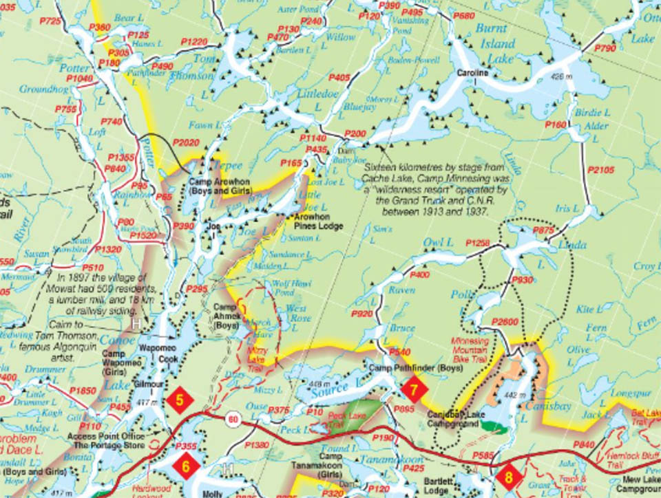
The computer program that controls the backcountry paddle-in reservation process assigns a 'body-of-water' or 'section-of-river' number to various lakes, parts of lakes and stretches of rivers. Each numbered 'body-of-water' or 'section-of-river' has a different number of reservable campsites. For example, while 'Lake Example' may have 10 campsites indicated on the official Canoe Route Map, the system may only allow for 8 reservations on that lake on any one night. The reason for the difference in numbers is that a percentage are kept 'open' to cover situations such as illness or being wind-bound. Specific paddle-in campsites can not be reserved, only access to an open campsite on the reserved 'body-of-water' or 'section-of-river'. Right: Here's an excerpt from the map that now appears in the reservation website .... Most of the lake names, as shown on the official Canoe Route Map, coincide with system's reservable 'bodies-of-water'. However, there are instances in which a lake may be divided into more than one CAMIS reservable 'body-of-water'. In the case of navigable rivers and creeks, they may be broken down into sections .. each one having its own 'section-of-river' number which contains a specific number of reservable campsites. Again, specific campsites can not be reserved, only access to an open campsite on the reserved 'section-of-river'. Without all the 'sections of rivers', contiguous 'bodies of water' and their precise demarcation lines being shown on the map .. the reservation process and the actual canoe-tripping experience can still be a bit imprecise in these instances. As a result, one is cautioned that when making one's reservation or booking at an access point office, one should ask the staff person what the exact name of the 'body-of-water' or 'section-of-river' is, and what any geographic limitations (demarcation lines) for it are. At the same time, it would also be prudent to mark your map with the same geographic extents (demarcation lines) .. so that you can recognize them as you travel on your trip. The online reservation system has undergone a recent redesign (Winter 2020), such that each 'body-of-water's' total number of campsites reserveable and the current number still available are no longer indicated! Numerous requests have been made to have this feature returned to the online mapping feature. Whether it will be re-introduced is uncertain at this time! The official online reservation system is accessible at https://reservations.ontarioparks.com |
||
Route Planning Algonquin canoe trips are usually planned with either an official Canoe Routes map or a similarly detailed map spread out on a table, with pencil and paper in hand .. or by accessing its online version. Usually, a general area and its corresponding "Access Point" are chosen as the starting point. Right: This is the kind of detail found on the official "Canoe Routes" map. An updated hardcopy purchase and an older online version can be accessed here . From the Access Point on, the daily paddling and portaging distances and times become the deciding factors. At the outset of the planning process, you should have an honest awareness of your physical ability and your personal preferences. Do you want a 'grand tour' seeing as many lakes as possible, being early to rise and late to sleep? Or, do you want a leisurely trip, with opportunities to explore shorelines, search out wildlife, fish, swim and lay about? Your expectations, combined with your abilities and the potential demands of each watercourse and portage, should determine the "location" at which you plan to be each evening. Unfortunately, its not a simple matter of scaling your maximum capabilities onto an official "Canoe Routes" map. There are a number of "variables" that don't show up on such a map, but which can adversely affect your comfort and safety. They include topography of portages, wind speed, wave height, rainfalls and extremes of temperature. The actual roughness of portages(rocks, roots and/or muck) are typically learned from those who have already travelled them before. This information can be gleened from personal contacts, printed accounts and online trip-logs. A period of rainfall can turn a rocky portage into a slow and slippery affair, demanding much more time to carefully maneuver. Likewise, a lowland portage can become a struggle through mud and over slippery boardwalks. Wind speed is truely variable. There are two generalizations to remember ... the prevailing wind is out of the northwest and wind tends to build through the afternoon and drop off in the evening. Unfortunately, these are only generalizations. A high wind out of the south is no less dangerous than one out of the north. And no established storm is going to observe a lull just because the sun is setting. Because a lake is small doesn't mean that it can't have powerful wind whipping across it. If a lake is located at the downwind end of a marsh, bog or valley, the wind will be quite high before it even arrives at open water. For the same reason, what may appear on a map to be a narrow, twisting and sheltered creek may have large open areas of windswept bog-mat or grass on either side that rise only a foot above the creek and offer no appreciable wind protection. In addition, such creeks often twist back and forth upon themselves with much more actual paddling distance than the map portrays. 
Topography can combine with the wind to produce still another annoying effect. There's no certainty that a west wind will be blocked by the shore of a long, narrow lake that runs at 45 degrees to the wind. Shorelines, ridges and hills have the annoying habit of deflecting and channelling wind. It's a wise move not to plan your trip distances and times straight down the middle of lakes. Generally speaking, its safer and more practical to plot your route along the west and north shores, or incorporate corresponding wind-shelter restspots behind obliging islands. Right: An very impressive alternative map is produced by Maps By Jeff. It can be accessed and purchased here . Even beavers' dam construction can raise water levels and flood previously dry portages. Alternatively, a collapsed beaver dam can transform a navigable pond into a morass of muck. Low water levels typically develop through the second half of summer. An enjoyable early summer river trip, if repeated in August may be an exercise in carrying your canoe along exposed muddy or rocky creek and river bottoms. A period of drought can worsen this condition. Arriving at your destination both wet and in the dark is far from an enjoyable end to the day. Its much preferred to have your camp pitched, a good meal eaten, dishes washed and the next day's drinking water prepared ... all before a lazy rest in front of the sunset and campfire. If the weather does turned on you, at least you'll have the "buffer" to fall back on.
| ||