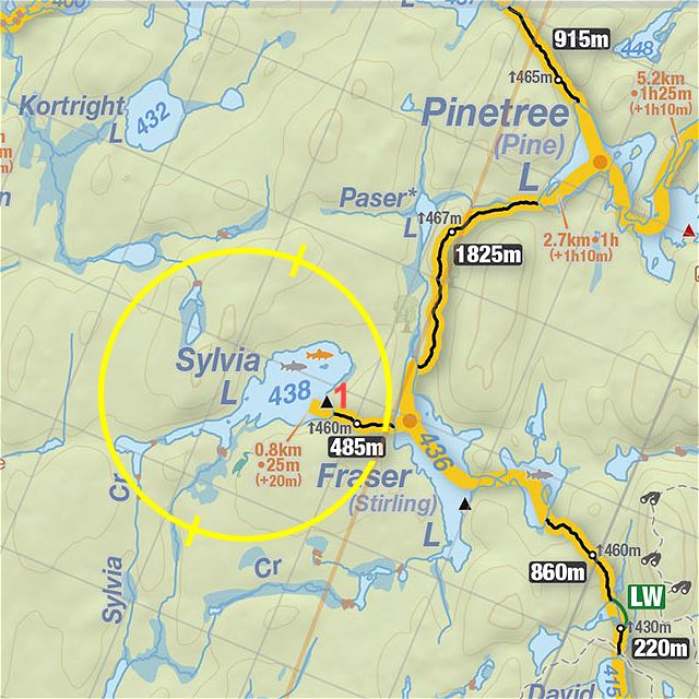
 485m Portage - Fraser To Sylvia Lake
Length of portage: 485m
Portage maintenance regular or low: Low.
Elevation above Sea Level @ Fraser Lake is 436 meters.
Elevation above Sea Level @ Sylvia Lake is 438 meters.
Difference in elevation: 2 meters.
Elevation of highest point: 460 meters. Overall rise/fall: 24 meters.
Landing at Fraser Lake
Topography of under-water approach: small, shallow, muddy bay.
Impediments to disembarking from and/or unloading a canoe: The bank is about 2' above the water line consisting of eroded forest floor giving way to some exposed, slanted, flat rock at the water line. Deep, sucking mud is what lies beneath the boat. The exposed rock slants into the water, so footing is tricky.
Portage Trail
General description: A low maintenance portage but easily navigable.
Impediments to travel: A 25M rise to the halfway point will get your blood pumping in a hurry. Several blow-downs that were climbed over without putting the canoe down. The last 25M towards Sylvia Lake are very steep and rain has eroded the trail exposing stones, and tree roots.
Landing at Sylvia Lake
The portage trail leads to a proposed landing site. But there were debris and poorly placed rocks, making access and loading difficult. Instead, there is another suitable location 4M to the north, which is still not ideal but easier than the initial location.
If anyone has photographs of this portage, please submit them so this record can be illustrated.

Thanks to Jeffrey McMurtrie of Jeff'sMap for supplying the base-layer map component by Creative Commons licensing.
Submitted by "scratchypants" (forum handle), visited August 24, 2019, submitted September 3, 2019