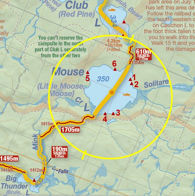
 Club Lake To Mouse Lake Portage
Length of portage: 610 meters.
Portage maintenance regular or low: Regular.
Elevation above Sea Level @ Club Lake is 334 meters.
Elevation above Sea Level @ Mouse Lake is 350 meters.
Difference in elevation: 16 meters.
Elevation of highest point: 354 meters. Overall rise/fall: 20 meters.
(Above data is extracted from 'Jeff's Map')
Landing at Club Lake
Co-ordinates of location: N46Ḟ 01.971' W78Ḟ 43.593'
Topography of under-water approach: Medium and large rocks.
Impediments to disembarking from and/or unloading a canoe: Medium and large rocks. The landing is strewn with these rocks. Unloading, and carrying the canoe to the haulage area is a strength and balancing act.
Topography of the ascending grade: Slight grade. Rocks and roots lead to the start of the trail.
Impediments to moving gear to portage trail: Rocks and roots ...
This was an impressive waterfall in Aug 2009. The landing is to the right ...


Portage Trail
General description: The beginning of the trail is a steep climb, then levels for a rather nice walk.
Topographical impediments to travelling: Both ends of this trail have some rocky and rooty sections.
Areas susceptible to impact by periods of rain or beaver flooding: None noticed.
Landing at Mouse Lake
Co-ordinates of location: N46Ḟ 01.732' W78Ḟ 43.517'
Topography of under-water approach: Shallow water, sand.
Impediments to disembarking from and/or unloading a canoe: Once out of the canoe, there are some large rocks to get over to the haulage area.
Topography of the ascending grade: Some rocks and roots, slight grade.
Impediments to moving gear to portage trail: Once at the haulage area, no impediments.
Approach to portage, rocks pose no problem ...


Thanks to Jeffrey McMurtrie of Jeff'sMap for supplying the base-layer map component by Creative Commons licensing.
Submitted by Chris Taylor, visited September 2014, submitted October 26, 2014