 Stratton Lake Campsite #20 Lat.-Long.: N45 51 21.7 W77 44 40.6 GPS-WGS 84: 18T 286930 5081715
 Landing
Topography of under-water approach: Sandy/small pebble beach landing. View is to the southwest.
Impediments to disembarking from and/or unloading a canoe: None.
Topography to tent sites: Short tapered rise of 2' to campsite, no impediments. Tenting area flat, as is the kitchen/firepit location..
Campsite's beach landing area .. vista is to the southwest ...

![]()
Firepit area, looking toward west end of lake ...

![]()
Campsite
Campsite maintenance: regular
Size of open area: 80' x 60'.
Extent of tree cover: 90% canopied over tent/kitchen area.
Degree of levelness: 95% flat.
Number of level tent sites: Two 3 person tents.
North exposure: Protected from the north winds, as campsite is bordered by mixed forest to the north, east and west.
East exposure: Protected from east winds as campsite backs on to mature evergreen and deciduous forest.
South exposure: Open to the south. No beach lounging area .. too narrow and bushy.
West exposure: Campsite faces west. However the site is located in the narrow end of the lake where it would be protected from any strong west winds due to the lack of open water.
Tenting/Tarp area, view is east from the campfire. Note the thick mixed forest behind the site ...

![]()
Wire food-pack cable, 10' high, located 50 meters east of the campsite ...

General description: Poor campsite due to the limited sun exposure. Proximity to shallow and sheltered end of the lake promotes mosquito and deer fly numbers during bug season. Campsite had nothing remarkable - no grill and no table. Logs around firepit were poor seating quality. Firepit well protected from any wind direction. Easy landing and campsite access. You can see the old train bridge from the site .. back up towards portage to Grand Lake. Food-pack wire-line erected 10' up from ground .. to the south of campsite for hanging food pack(s). Thunderbox is located east of campsite
Overall accessibility: Good.
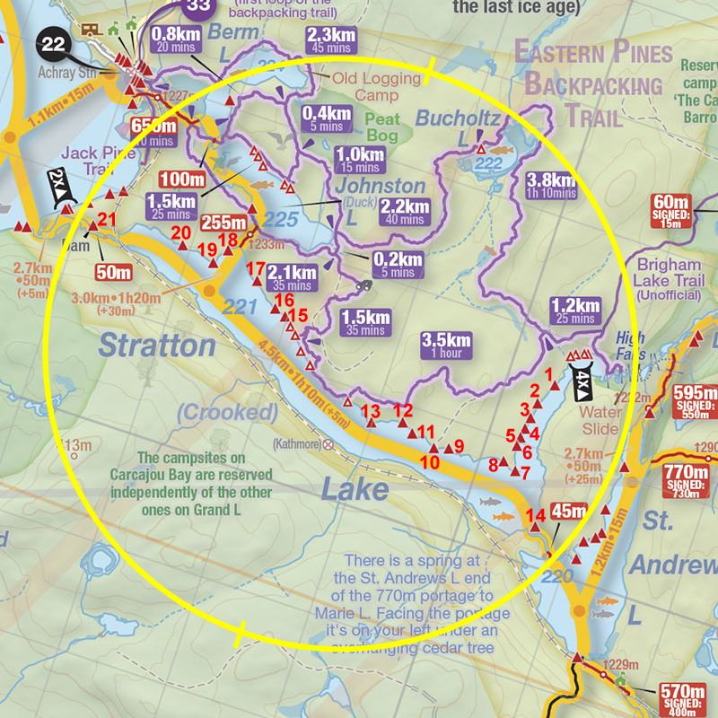
Thanks to Jeffrey McMurtrie of Jeff'sMap for supplying the base-layer map component by Creative Commons licensing.
Submitted by Stephen Molson .. Visited July 23rd, 2009 .. Submission Aug. 6th, 2009