 Stratton - St. Andrews Portage
Portage Trail
Length: according to CRAPP Map .. 75 meters
Portage maintenance: regular
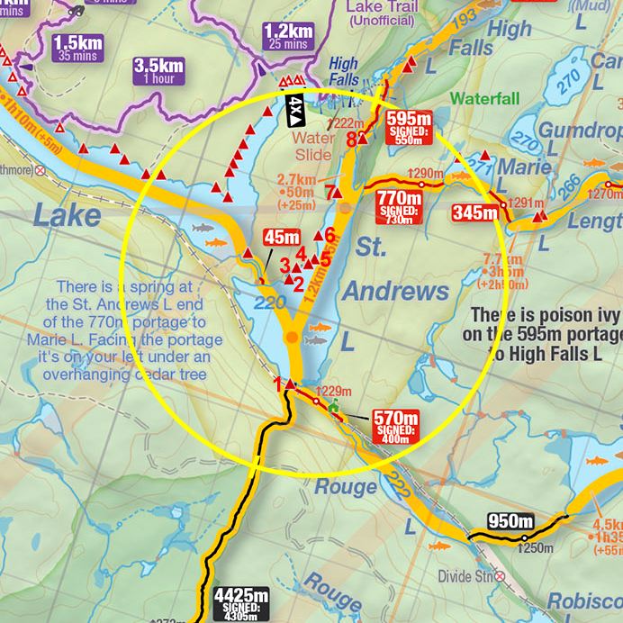
Landing at Stratton Lake .. Lat. N45 50 36.1 .. Long. W77 41 37.8
Landing at St. Andrews Lake .. Lat. N45 50 34.2 .. Long. W77 41 36.5
Elevation above Sea Level @ Stratton: 223 m
Elevation above Sea Level @ St Andrews: 222 m
(According to Jeff McMurtrie's Maps)
Rise/Fall Overall: Highest point on the portage is roughly 5 meters above the level of St. Andrews Lake .. just in from the Stratton Lake landing.
Landing at: Stratton Lake (upstream)
Topography of under-water approach: Shallow boulders some emergent and some logs. There is a small creek to navigate from Stratton Lake before you hit the portage landing.
Available surface area for managing canoes: Sufficient room for 2 canoes + gear at a time, larger parties will have to wait offshore. But the portage is short and quick. However one can also 'line' the river joining the two lakes, depending on water level.
Impediments to disembarking from and/or unloading a canoe: None .. nice flat rock to pull up on however there are some overhanging cedars.
Topography of the ascending grade: Large shield rock mass that rises from the landing (approx. 4 meters), then you are downhill to St Andrews. Firm footing throughout.
Impediments to moving gear to portage trail: Just the immediate rise of rock and some exposed roots.
From on top of the rock, overlooking the canoe landing on the Stratton Lake side ...

Sign to St Andrews Lake from the Stratton Lake side ...

![]()
River that is lineable (depending on water levels) to St. Andrews Lake from Stratton Lake ...

![]()
Landing at: St. Andrews Lake (downstream)
Topography of under-water approach: Deep rock on St. Andrews end.
Available surface area for managing canoes: Room for only 1 canoe + gear from 2 canoes. However one can also 'line' the river joining the two lakes, depending on water level.
Impediments to disembarking from and/or unloading a canoe: Larger boulders and deep water - a little tricky for those who want to keep their feet dry.
Impediments to moving gear to portage trail: None
St Andrews Lake landing (July '09) ...

St Andrews Lake landing (September '09) ...

Looking inland to the portage from the St. Andrews Lake landing (July '09) ...

Portage Trail
General description: A nice easy portage, firm ground or rock, a few roots.
Topographical impediments to traveling: None.
Areas susceptible to impact by periods of rain or beaver flooding: None.
Thanks to Jeffrey McMurtrie of Jeff'sMap for supplying the base-layer map component by Creative Commons licensing.
Submitted by Stephen Molson, October 6, 2009