 Snow Lake Campsite #1
This campsite is located just outside the park. It is located on a canoe route which is portrayed on the official online 2015 Canoe Route Map and which runs between Smoke Lake and Park Lake. While the campsite was portrayed on official park maps during the 1990's, it was subsequently removed from the maps. While Snow Lake is identified as Reservation Zone #154, it is now described as having zero campsites and being "outside park, campsite closed".
Landing
Topography of under-water approach: 2 feet deep sandy bottom, with only 1 1/2 foot or so to stand on.
Impediments to disembarking from and/or unloading a canoe: Quite a quick drop-off into the lake .. not an easy landing.
Topography leading to tent sites: approx. 3 foot grade up to two tentsites.
 |
|
| - Difficult landing area. | |
Campsite
Regular or low-maintenance: Low maintenance (nolonger maintained)
Size of open ground area: 4 x 15 feet.
Extent of tree cover: Open canopy, dead pines.
Degree of levelness: Uneven.
Number of tent sites: 1 flat tent site and 1 uneven tent site.
North exposure: Not open.
East exposure: Not open.
South exposure: Fully open exposure.
West exposure: Slightly open to the lake.
 |
|
| - One of two tent sites. | |
 |
|
| - Open area. | |
Overall accessibility: Not easy. Its unmaintained and very small, with fern growth over the tent sites
Note: Jeff's Map indicates two sites on Snow Lake. the first one (west) couldn't be located. The second one is further down the lake than indicated.
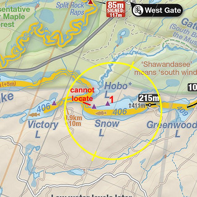
Thanks to Jeffrey McMurtrie of Jeff'sMap for supplying the base-layer map component by Creative Commons licensing.
Submitted by: Wanda Spruyt .. Visited September 1st, 2015 .. Submission September 28th, 2015