 Sec Lake Campsite #7
Landing
Topography of under-water approach: Sloping shield rock
Impediments to disembarking from and/or unloading a canoe: Potential of slipping should the rock be wet, but no logs or mud.
Topography to tent sites: Hard packed earth, shield rock with some large boulders. Tent area flat, kitchen/cooking areas on a slight grade but not an issue.
Landing areas, vista is looking West. Islands' shoreline visible in the background ...

![]()
Kitchen and partial firepit area, southern vista ...

![]()
Northern vista from campsite. Note trail leading to neighboring campsite that's due north of this position ...

![]()
Tenting location, north east of kitchen area ...

![]()
Campsite
Campsite maintenance: regular
Size of open area: 60' x 50' .
Extent of tree cover: 70% canopied
Degree of levelness Kitchen area flat, tent pitched location very slightly angled.
Number of level tent sites: Two 3-person tents
North exposure: Good tent and firepit protection from any miserableness from the North. Landing site is exposed to the north however.
East exposure: Good protection from easterly winds. Tenting area protected by mixed young forest.
South exposure: Good southerly exposure.
West exposure: Good western exposure, lots of afternoon sun, decent sunning rock at landing area.
General description: A good site, small and compact. Level enough and lots of firewood to be had. Well travelled path (70m) to neighboring campsite makes this one a good choice if traveling with a large party (exceeding 9 per site) and proximity is desired. Nicely protected from both the North and the East, OK swimming off rock into deeper water. No table on site. However remnants of one that was torn down could be seen. Crapper is a 'squatbox'.
Overall accessibility: Good.
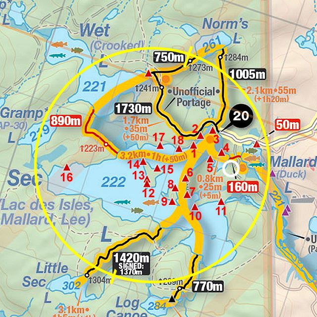
Thanks to Jeffrey McMurtrie of Jeff'sMap for supplying the base-layer map component by Creative Commons licensing.
Submitted by Stephen Molson .. Visited Sept 2008 .. Submission Jan. 29 2009