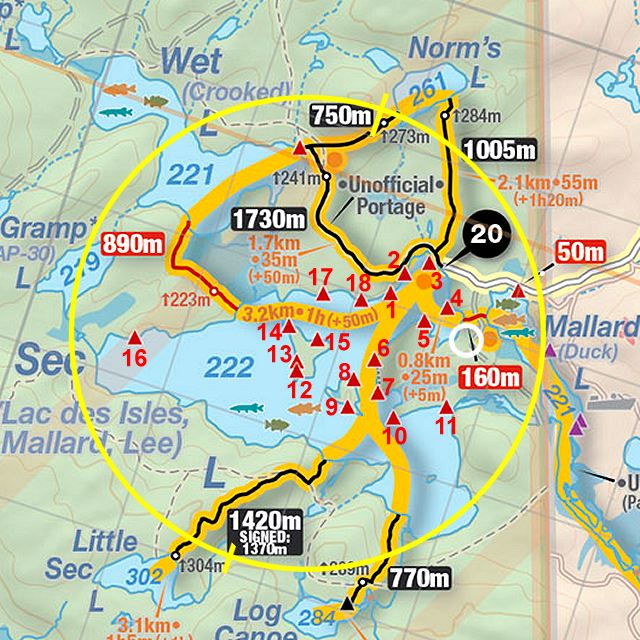
 Portage 890 meters - Sec Lake to Wet Lake
Length of portage: 890m
Portage maintenance regular or low: Low.
Landing at Sec Lake: N45 49 25.6 W77 33 29.5 Elevation above Sea Level: ~215 m
Landing at Wet Lake: N45 49 39.6 W77 33 52.2 Elevation above Sea Level: ~222 m
Rise/Fall Overall: 7 meter rise from Sec Lake to Wet Lake. Highest elevation was 224 meters
Cross Section of portage elevation changes ...
Landing at: Sec Lake Lake (downstream)
Topography of under-water approach: Shallow muddy weedy area on landing with shrubs/emergent Pickerel Weed straddling the shore makes footing cumbersome.
Available area for managing canoes: Room for 2 canoes, with one pulled up on shore. Adequate gear storing/management areas up on bank.
Impediments to disembarking from and/or unloading a canoe: Small, weedy (in summer) and narrow landing. Emergent Pickerel Weed plants and shrubs along shore to walk over. High water levels may put the landing closer to the tree line but no emergent weeds. Below water the ground is soft sinking mud.
Impediments to moving gear to portage trail: Narrow and emergent weed lined landings (depending on time of year) made gear management tight, but adequate space for storage and movement.
Canoe landing on Sec Lake looking east ...

Portage Trail
General description: Well trodden portage, good dry footing throughout, some boulder and root sections where the forests narrows closer to the Wet Lake end. No wet areas encountered other than at landings.
Topographical impediments to traveling: None.
Areas susceptible to impact by periods of rain or beaver flooding: Early spring typical conditions would be high water on landing areas and potential muddy footing at start/end. Mid-way along the portage the trail could experience lite flooding in early Spring on account of marsh proximity to the east but no flooding section encountered during hat trip.
Topography of the ascending grade: Topography of landing and subsequent ascending grade on the Sec side is relatively flat. An initial slow taper rise of 4 meters over 100 m ground distance, a total elevation change of only 7 meters over its entire length. No steep climbs anywhere along the portage Wet lake landing is generally flat and portage sufficiently wide through the majority of the walk. One angled tree forced an easy 4 meter detour onto a secondary trail. Footing is firm throughout, no flooding or wet sections encountered.
Landing at: Wet Lake (upstream)
Topography of under-water approach: weedy with emergent plants, an emergent log framing the landing that juts out into the water makes for an adequate pier for boat loading.
Available area for managing canoes: Depending on water levels 2 canoes, one being in the water with adequate gear storage.
Impediments to disembarking from and/or unloading a canoe: Small, weedy (in summer) and narrow landing. Emergent Pickerel Weed plants and shrubs along shore to walk over. High water levels may put the landing closer to the tree line but no emergent weeds.
Portage landing at Wet Lake ...

Thanks to Jeffrey McMurtrie of Jeff'sMap for supplying the base-layer map component by Creative Commons licensing.
Submitted by Stephen Molson ... January, 2010