 Red Pine Bay Campsite #1
Landing
Topography of under-water approach: Deep water just off shore
Impediments to disembarking from and/or unloading a canoe: A few sloped, flat shield rocks both on shore and just offshore partially submerged.
Topography leading to tent sites: brief steep bank could be slippery when wet, then gentle grade to site. Perhaps 8’ vertical difference from water level.
View of the gently sloping rock surfaces.

![]()
Campsite
Regular or low-maintenance: regular
Size of open area: approximately 60’ X 60’
Extent of tree cover: 86%
Degree of levelness: gentle “saddle” with a couple tent areas that are mostly flat.
Number of tent sites: two suitable for three man tents, perhaps an extra site to the northeast of the clearing.
North exposure: protected
East exposure: light protection from east winds. Good views of sunrise over Redpine Bay
South exposure: protected
West exposure: protected – good view on the other side of the island
General description: A beautiful setting for a campsite – I give it a grade of “A”. Adequate tenting area for 2-3 tents, sound firepit with two large log benches and one stone slab table in the kitchen area. Canopy allows a dappling of sunlight through but generally protected and covered. Views out the front and back are beautiful (weather permitting). Average site for star gazing, below average for swimming. A pretty site with mature conifers throughout and a comfortable layout. Small-ish but could support a group of 5 or 6 comfortably.
Overall accessibility: good.
View of the kitchen and tenting area facing south.

![]()
View of the kitchen and tenting area facing north.

![]()
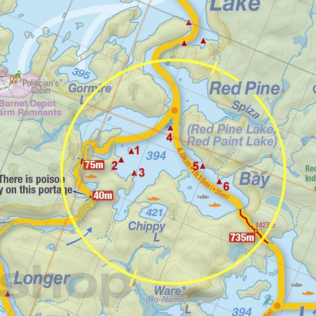
Thanks to Jeffrey McMurtrie of Jeff'sMap for supplying the base-layer map component by Creative Commons licensing.
Submitted by Joe Zaleski, January 2011 .. visited May 2010.