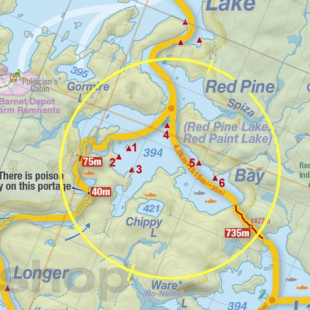
 Portage 75m .. 1st Upstream Between Red Pine Bay and Longer Lake, on the Petawawa River
Portage
Location: 1st portage upstream between Red Pine Bay and Longer Lake, on the Petawawa River.
Length of portage: 75 meters
Portage maintenance regular or low: Regular.
Elevation above Sea Level at Petawawa River Upstream: 395 meters
Elevation above Sea Level at Petawawa River Downstream: 394 meters
Difference in elevation: <1 meter drop between Petawawa River and Red Pine Bay
Elevation of highest point: 401 meter.
Portage Trail
General description: Narrow trail, short up and over. Rocky and steep last section on the downstream end closer to Red Pine Bay landing. Swift can be run downstream and lined upstream if desired when water level/flow is suitable to individual’s skillset.
Topographical impediments to traveling: None other than the steep rocky section at the downstream end of the portage.
Areas susceptible to impact by periods of rain or beaver flooding: At landings only.
Upstream Landing on Petawawa R.
Co-ordinates of location: N45 49 29.8 W78 40 04.7
Topography of under-water approach: Shallow sandy and rocky shoreline. Slight current (<1 km/hr) at landing was not an issue during Summer water levels.
Impediments to disembarking from and/or unloading a canoe: None during normal Summer water levels.
Topography of the ascending grade: A slight rise of about 3 meters from the landing before the trails flattens out and then drops 4 meters to the Red Pine Bay landing.
Impediments to moving gear to portage trail: None.
Upstream landing on the Petawawa River, looking south ...

![]()
The upstream side or beginning of portage from Petawawa R. .. heading to Red Pine Bay ...

![]()
Looking north-west, downstream to the top of the swift ...

![]()
Downstream Landing at Red Pine Bay
Co-ordinates of location: N45 49 32.2 W78 40 05.2
Topography of under-water approach: Shallow and rocky.
Impediments to disembarking from and/or unloading a canoe:None during normal Summer water levels. Expect stronger current, higher water during spring conditions.
Topography of the ascending grade: 3 meter steep rocky and shaded rise from landing over 10 meters before trail flattens out and begins the easy downward grade to Petawawa River put-in.
Impediments to moving gear to portage trail: Rocky landing with little flat gear storage area – prop the packs up on large rocks or haul up the bank where the portage flattens out. Sufficient space for only two canoes + gear at a time on landing.
Downstream view from just above landing on the Red Pine Bay end ...

![]()
Upstream view of the Petawawa River, from the landing on the Red Pine Bay end ...

![]()
Thanks to Jeffrey McMurtrie of Jeff'sMap for supplying the base-layer map component by Creative Commons licensing.
Submitted by Stephen Molson .. Visited July 2009 .. Submitted March, 2010