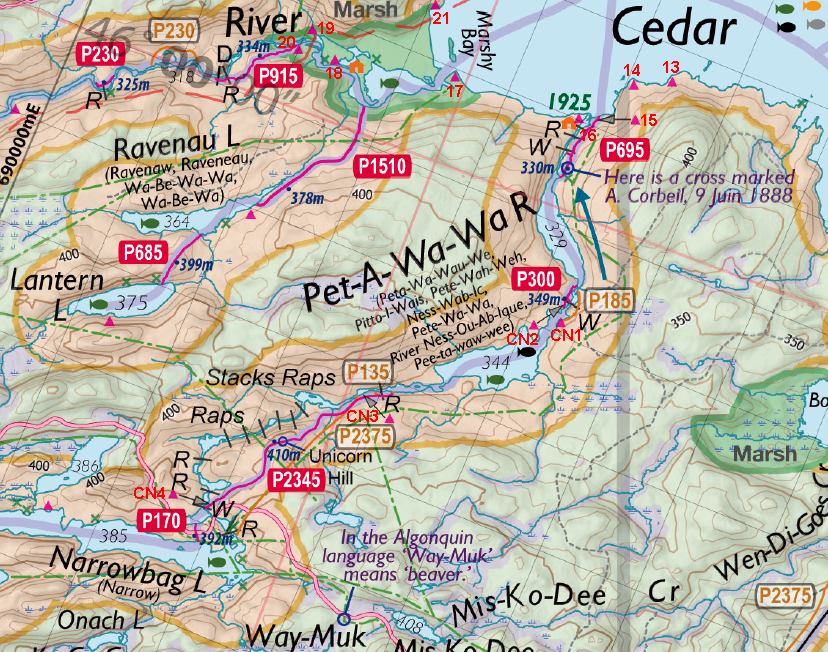
 Portage 2345 meters - on Petawawa R. (Between Narrowbag and Cedar L., south of Brent)
Length of portage: 2,345 meters (Unicorn Hill)
Portage maintenance regular or low: Regular.
Elevation above Sea Level @ Petawawa River ~ 344 meters
Elevation above Sea Level @ Petawawa River ~ 392 meters
Difference in elevation: 48 meter drop between Petawawa and Petawawa
Peak portage elevation: ~ 410 meters
Portage Trail general description: VERY STEEP SLOPE UP. Rocky and rooty to the top of Unicorn Hill. Winding and steep. This is a strenuous portage and care should be taken. When you reach the peak of Unicorn Hill, there are 2 canoe rests and benches. It is mildly hilly and slightly down hill from there to the end. The portage peaks at 410m for a total difference in elevation of 66m over a short distance.
>>> Editors note: Photographs of this portage are welcomed!
Topographical impediments to traveling: Steepness
Downstream Landing at: Petawawa RiverTopography of under-water approach: Rocks
Impediments to disembarking from and/or unloading a canoe: Rocks
Upstream Landing at: Petawawa River
Topography of under-water approach: Rocks
Impediments to disembarking from and/or unloading a canoe: Rocks
Thanks to Jeffrey McMurtrie of Jeff'sMap for supplying the base-layer map component by Creative Commons licensing.
Submitted by Sean Rowley, visited 2009, submitted Sept 12, 2009