 Nipissing River - High Falls - Campsite #2
Landing
This site must be hiked to since it is along the High Falls portage approximately 150 meters upstream of the downstream end of the portage. Landing at the downstream end is OK - some swift water to negotiate when working upstream towards the landing and some shallow gravel/cobble areas as well. Landing is not large but will accommodate a couple of canoes.
Impediments to disembarking from and/or unloading a canoe: No significant impediments
Topography to tent sites: Relatively level trail with one area washed out, with limited space to walk on shore.
Campsite
Regular or low-maintenance: Regular
Size of open area: Small - perhaps four meters by 8 meters.
Extent of tree cover: Approximately 30 percent. Will experience late sunrise and early sunset due to topography
Degree of levelness: Very level.
Number of tent sites: 2 small ones, and possibly a third one on the trail.
North exposure: Protected by the forest.
East exposure: Generally protected by river valley.
South exposure: Protected by the forest.
West exposure: Generally protected by river valley.
Firepit area ...

![]()
Riverside tentsite ...

![]()
Trailside tentsite ...

![]()
General description: This cozy site is tucked in between the river and the portage, about two or three hundred meters downstream of the actual falls and about 150 meters from the downstream end of the portage. The sound of the river's rapids will be a constant background soundtrack that you will experience here, along with a very pleasant view of the river as it cascades through the pine forest. The site must be hiked to from either end of the portage. The campsite has one large tent site right next to the river and another smaller site cut out from the forest on the other side of the portage. The fire pit is of comfortable size for a site like this and is a very simple ring of rock with a couple local logs hauled up for seating. There is a large limb that overhangs the river that will work well as a food hang.
Overall accessibility: Good, but not a canoe-up site. However, if you've reached here, you are used to portaging.
Looking downstream ...

![]()
Looking upstream ...

![]()
High Falls Reservation Area (#515) ...
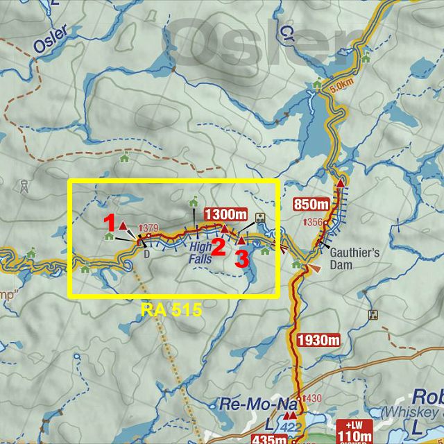
Thanks to Jeffrey McMurtrie of Jeff'sMap for supplying the base-layer map component by Creative Commons licensing.
Submitted by Joe Zaleski, October, 2013 .. visited October, 2013.