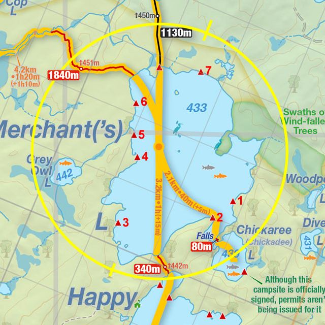
 Portage 1840m between Merchant Lake and Big Trout Lake
Portage
Length of portage: 1840 meters
Portage maintenance regular or low: Regular.
Elevation above Sea Level @ Merchant Lake: 440 meters
Elevation above Sea Level @ Big Trout Lake: 405 meters
Difference in elevation: ~35 meter drop between Merchant Lake and Big Trout Lake
Elevation of highest point: 454 meters.

Portage Trail
General description: Good trail, well groomed with a few short up and down sections over the first half before trending down at a leisurely angle for the remainder to Big T. Not cart-friendly on account of boardwalks, roots and rocks and some uneven ground sections. Pink Lady Slipper orchids 30m up from the Big Trout landing. Seasonally dry, portage meanders through a secondary mixed growth forest with some mature pines and one grassy hilled section. Dwarf raspberries (with fruit), flowering orchids and sorrel growing along trail (early July).
Topographical impediments to traveling: None.
Areas susceptible to impact by periods of rain or beaver flooding: None encountered during summer travel. Spring will see higher waters at landings – most notably on the Big Trout side (shallow creek, low-land) and a few depressions/wet areas along the portage.
Upstream Landing at: Merchant Lake
Co-ordinates of location (optional): N45 46 48.8 W78 32 50.3
Topography of under-water approach: 2’ deep flat over shallow rocky bottom, some emergent rocks close to shore. Shoreline firm with grasses and rocks.
Impediments to disembarking from and/or unloading a canoe: None during normal Summer water levels. Doubtful there’d be an issue in spring water levels either.
Topography of the ascending grade: Portage begins along a flat grade and straight line through a mixed-growth evergreen forest.
Impediments to moving gear to portage trail: None. Lots of room up from landing for over 5 canoes + gear. Landing adequate to support 6 vessels on the water at a time.
Landing at Merchant L ...

Merchant Landing – seen from the water .. supplemental submission from Joe Zaleski (taken May 2010)

![]()
Beginning of portage from Merchant Lake, looking south west ...

Log hurdle on the portage .. supplemental submission from Joe Zaleski (taken May 2010)

![]()
Looking back across Merchant Lake, from the landing ...

![]()
Downstream Landing at: Big Trout Lake
Co-ordinates of location (optional): N45 46 54.6 W78 33 57.1
Topography of under-water approach: Shallow with some rocks, mud, silt and weeds during normal summer water levels. Landing is along a narrow creek shore prone to flooding @ high water. Two small active beaver dams to navigate over/pole through within 100 meters of landing.
Impediments to disembarking from and/or unloading a canoe: No natural obstructions during normal summer water levels. Likely more current during Spring water levels with water up to the bank over firm rocky ground.
Topography of the ascending grade: Flat for the first 250 meters from landings at Big Trout with a series of narrow boardwalks to navigate before the steady and fair uphill grade to the mid-point of the portage.
Impediments to moving gear to portage trail: Small landing will make managing the areas with many canoes an issue. Space for 3 canoes in the water at time, 2-3 up on shore + gear. There is a small flat gear-managing area up from the landing in a small clearing. Groups/individuals need to be organized and considerate to others here (e.g. we encountered a group that wasn’t either).
Landing at Big Trout Lake .. along a creek .. looking west ...

![]()
Landing at Big Trout, looking inland ...

Thanks to Jeffrey McMurtrie of Jeff'sMap for supplying the base-layer map component by Creative Commons licensing.
Submitted by Stephen Molson .. December, 2009