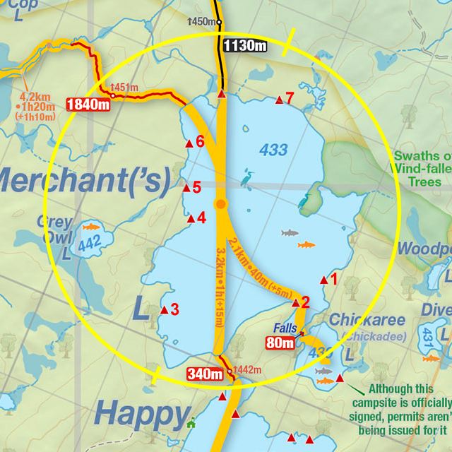
 Merchant Lake Campsite #1
Landing
Topography of under-water approach: North-West facing landing, over 3’ long boulders and granite shelf. Shoreline landing was a granite stair-step shelf, steep sided dropping into 3-4 feet of water along a narrow flat before further dropping into 40+ feet of water 50 feet out. One must approach the rocky cliff carefully when winds are an issue.
Impediments to disembarking from and/or unloading a canoe: Bracing may be required to avoid the rock outcropings from cliff on either extent of landing and to avoid vessel from being swept onto shallow 1 m wide rocky landing shelf (dependent on water level and winds). Low-hung cedars at landing as well – careful of your rods if they are exposed. Unloading/loading a challenge when wind is an issue. Sufficient room to bring up canoe and lay it flat up on shore just above landing.
Topography to tent sites: Relatively flat once you’re up on shore and off the landing’s rock face. Roughly 1.5 m in elevation from waterfront.
Campsite’s rocky, cliff-like landing ...

![]()
Campsite’s main tenting area ...

![]()
Looking out towards Merchant’s western shoreline ...

![]()
View of firepit area ...

Campsite maintenance: regular.
Size of open area" approx. 100’ x 50’.
Extent of tree cover: 70% canopied over tent/kitchen area
Degree of levelness: Fairly flat around firepit and tenting area.
Number of level tent sites: At least 3 flat sites adequate for3-4 man sized tents.
North exposure: Site and landing are moderately exposed to the north winds – site is located very close to shoreline with thin tree cover.
East exposure: Site and landing are protected from eastern winds as campsite backs-on to evergreen forest.
South exposure: Site and landing are moderately exposed to the south winds.
West exposure: Site and landing are fully exposed to the west winds. 20+ km/hr winds will make landings/push-offs challenging on account of the cliff-like nature of the shoreline here. Lots of sun exposure along campsite’s shoreline.
General description: Good, fairly flat campsite, decent kitchen area and well-protected and built firepit. Poor canoe landing on account of the cliff-like nature of the shoreline and the deep water. Good open space and lounging rocks along shoreline. Nice swimming area. A few mature white pines on site. Two rough-log benches around firepit. Many grills present. Great sunsets views and mid-morning to end of day sun exposure. Excellent location for lake vistas. Thunder box located east of campsite. No issues with firewood.
Overall accessibility: Fair.
Thanks to Jeffrey McMurtrie of Jeff'sMap for supplying the base-layer map component by Creative Commons licensing.
Submitted by Stephen Molson .. Submission March 6, 2009