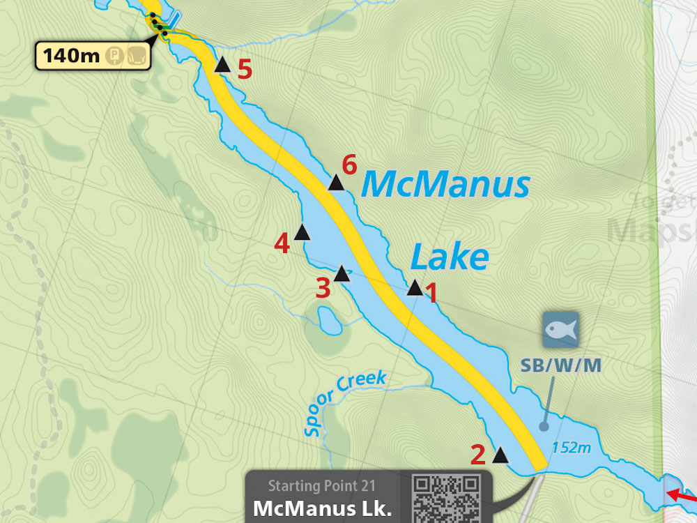
 McManus Lake Campsite #5
Landing
Topography of under-water approach: Fist-sized rocks/pebbles and sand. A few emergent large rocks just east of the landing are easy to avoid. Shoreline drops off about 20' feet from shore into 10-12' depth of water this time of year (November). Add a good 5 feet to that in the Spring. Very subtle current through narrows to campsite, will be more of an issue in Spring time and normal water levels.
Impediments to disembarking from and/or unloading a canoe: None - shallow pebbly beach provides good footing, very little current, water level was low however. Approach to the landing was from the north, north-west.
Topography to tent sites: Flat and open under canopy of tall red pine. Surrounding forest open due to late season and hardwoods 90% leafless. Tentsite up about 15-20' foot high from shoreline - 35 degree slope to navigate up from canoe landing., sand/earth footing.
Photo: campsite landing area, northern shoreline, looking north-west towards narrows to Smith Lake ...

Photo: SE vista taken off south end of campsite.
Small creek enters the lake behind site, draining unnamed pond ½ km to the NE ...

Photo: Campsite showing firepit and tent location. Note the openness of the young forest this time of year ...

Campsite
Campsite: Regular Maintenance
Size of open area: 80'+ by 20'+ feet of open ground.
Extent of tree cover: 70% canopied camping area.
Degree of levelness: slight angle to site, tent area flat.
Number of level tent sites: Three 3 man tents.
North exposure: Protected from the North winds and backs on to mixed forest.
East exposure: Somewhat protected from eastern winds. Tent and firepit location recessed in amongst the shoreline's forest.
South exposure: Nice southern view from shore. The lake is narrow. A south-west or north-east wind would make for a rougher lake. Good swimming site in Summer.
West exposure: Good western exposure, a few boulder outcrops and shoreline area free from overhead canopy to enjoy the sun.
General description: A nice enough campsite - furthest along on the north side of the shore. Unmarked on JM's map but is id'ed on Official APCR Map. Site is just downstream of the rapid section between lakes. No table, but there were downed logs for seating. Nice flat space for the NF tent, crapper is a box. Can hear the rapids at night when the winds are still, nice and soothing to sleep and wake-up to.
A little stream south of campsite was quaint and looked inviting for a walk-up to visit the lake that feeds it. Swimming may be good at the campsite - a dropoff off close to the sandy/pebbly shore and not many weeds seen. A bit of a sand beach and light current this time of year. However the current will be substantially stronger in the Spring and early Summer. Best campsite for the swimming would be the mid-lake one on south/west shore. It's built in the wildlife zone and has a very nice sandy extended point, which drops quickly to deep water. Risk that the local wildlife also find that spot inviting...No problem with firewood - many hardwoods 10-20 meters north of campsite.
Overall accessibility: Excellent at this time of year. Risk of faster and higher water to access this campsite May - July.
Submitted by Stephen Molson .. Visited: November 2008 .. Submission: Jan. 25, 2009Additional photos submitted by Tom Yates .. Visited: August 2008 .. Submission: Jan. 26, 2009
Looking back towards Smith Lake narrows ...

![]()

Thanks to Jeffrey McMurtrie of Jeff'sMap for supplying the base-layer map component by Creative Commons licensing.
