 McCraney Lake Campsite #1
This PCI record is comprised of photos taken by Barry Bridgeford in 2005 (during July high water) and by Wanda Spruyt in 2019 (during late September low water). While the earlier photos are potentially outdated, they do illustrate the impact of the passage of 14 years and the effect of lowered water levels. McCraney Lake has a run-off control dam at its outflow, which is capable of lowering levels in preparation of storing spring run-off water volumes.
Landing
Topography of under-water approach: South part of waterfront is a large sloped rock. North part of waterfront is comprised of numerous irregular rocks.
Impediments to disembarking from and/or unloading a canoe: Steep slope requires special care.
Topography to tent sites: Once the rock slope has been climbed, the campsite is generally flat except for pronounced tree roots criss-crossing a large part of it.
Campsite seen from the water in 2005 (photo by Barry) ...

![]()
Sloped rock landing during high water in 2005 (photo by Barry) ...

![]()
Same sloped rock landing during low water in 2019 (photo by Wanda) ...

![]()
Campsite
Campsite maintenance: Regular.
Size of open area: Approx. 40ft x 40ft.
Degree of levelness: Bumpy network of tree roots over 1/3 south and west of the firepit. Otherwise level.
Number of level tent sites: 2.
North exposure: Trees.
East exposure: Lake.
South exposure: Shoreline and trees.
West exposure: Small trees and a buggy bay to the northwest.
General description: A small campsite without the benefit of a point, afternoon sun or sunset view.
Overall accessibility: Not ideal.
One of the tentsites is at the rear, 2005 (photo by Barry) ...

![]()
Over fourteen years, the soil has compacted and the roots are 'worse' (photo by Wanda) ...

![]()
There's room for a second tentsite closer to the firepit (photo by Wanda) ...

![]()
This is the view of the lake from behind the firepit, 2005 (photo by Barry) ...

![]()
Looking across the firepit to the northeast, 2019 (photo by Wanda) ...

![]()
Down on the low-water beach, looking north, 2019 (photo by Wanda) ...

![]()
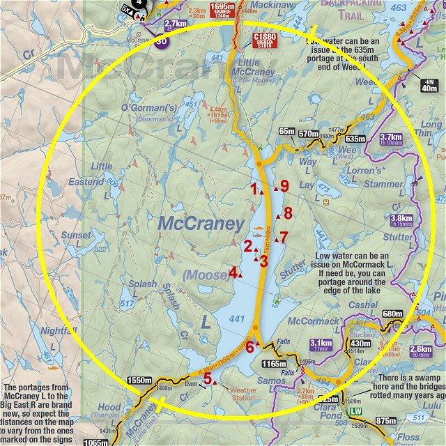
Thanks to Jeffrey McMurtrie of Jeff'sMap for supplying the base-layer map component by Creative Commons licensing.
Joint report courtesy of Wanda Spruyt and Barry Bridgeford .. Visited 2005 and 2019 .. Submission Dec. 4th, 2019