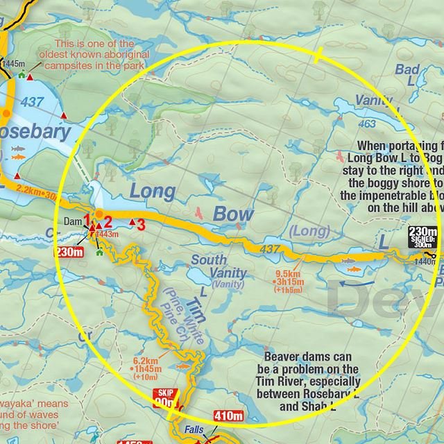
 Longbow Lake Campsite #1
Landing
Topography of under-water approach: Very gradual, shallow sloping sandy/pebbly beach
Impediments to disembarking from and/or unloading a canoe: None - no obstructive rock, tree(s) or shrubery at landing, very slight downstream (flowing south) current. Some emergent vegetation (arrowhead/lilly pads) frame the landing.
Topography to tent sites: Flat, large area of hard-packed dirt, some roots. Trees widely spaced.
Picture of campsite's canoe landing area. Note sandy and pebbly landing and the high water levels ...

![]()
Northern vista taken from canoe landing on Longbow lake. Rosebery Lake a few hundred meters to the west of far point and through channel. ...

![]()
Firepit & kitchen area (note table). Large blade(?) artifact to the left of spruce tree acting as windbreak. Portage to Tim River viewable in background ...

![]()
Picture of tenting area, looking south south-west ...

![]()
Campsite maintenance: regular.
Size of open area: 120+' x 80'+.
Extent of tree cover 80% canopied, primarily evergreens
Degree of levelness 90% flat terrain within open area.
Number of level tent sites: Three 3-4 person tents (max 9 peeps per campsite)
North exposure: Well protected from any wind direction - recessed into narrow southern bay, above the rapid section where the Tim R flows down South-East towards Shippagew Lake.
East exposure: Very well protected from the eastern winds/rain by coniferous forest.
South exposure: Southern view is limited to 100 meters down towards the Tim River. Well protected from any wind direction.
West exposure: Good western exposure, however the horizon is limited due to proximity of western shoreline.
General description: Very large flat and open tenting and kitchen area but privacy is sacrificed due to proximity to Tim River portage 20 m to the east of camp spot. A rough narrow but stable table has been created between two evergreens, firepit bordered on ˝ its length by rough log benches.
Campsite is of historical significance as noted by the numerous artifacts at campsite and scattered along portage and adjoining field/clearing to the Tim River.
Swimming area (canoe landing) is small and shallow (4') - likely even more shallower in a normal (re: drier) season. Can wade the rock/sandy bottom to the far shore directly across from campsite. Weedy areas down, across and upstream of site, but kids found the slight current enjoyable to sit and hang-out in. Good all-around protection from wind and rain. Both fresh bear and moose sign spotted, in addition to many blueberries and some raspberries in clearing area (hmm, I wonder if there's a link..). Crapper is a 'squatbox'.
Overall accessibility: Excellent accessibility. Easy landing and small sandy/earthy ledge to walk up (4' vertical) from canoe landing.Some of the historic artifacts found at site (at campsite under red pine) .. old tunic buttons, glass bottles, belt buckle and other classic items ...

![]()
Thanks to Jeffrey McMurtrie of Jeff'sMap for supplying the base-layer map component by Creative Commons licensing.
Submitted by Stephen Molson .. Visited July 1, 2008 .. Submission Jan. 29 2009