 Lawrence Lake Campsite #1 Lat.-Long.: N45 29 52.9 W78 31 05.0
Landing
Topography of under-water approach: South landing is nestled in a perfect little sandy-bottomed shallow and well protected nook sized for one or 2 canoes/kayaks. There is a secondary landing on the east shore of the same point, nestled up against a steep grassy bank below firepit area. No obstructions to landing at high water - thin protective rocky emergent spine borders the landing on the south-west side, which provides some basic wind protection.
Impediments to disembarking from and/or unloading a canoe: None I could see at spring water levels, from the main landing.
Topography to tent sites: 12 meter walk uphill, along a firm bottom path of earth/roots/scattered rock to campsite and firepit area. Good footing throughout. Roughly 4 meter rise in elevation from waterfront.
Campsite's southern landing area, view is south-west ...

![]()
Campsite's 3 benches and tent area (behind and to the left of last bench), view is north ...

![]()
From campsite looking east towards small back-bay and lake's eastern extent ...

![]()
Down the western arm of Lawrence Lake from campsite's canoe landing ...

![]()
Campsite
Campsite maintenance: regular
Size of open area: 30' x 70'.
Extent of tree cover: 75% canopied over tent/kitchen area.
Degree of levelness: Fairly flat around firepit and tenting area
Number of level tent sites: At least 2 flat sites adequate for 3-4 person tents. Another pseudo-tenting area and firepit located north of campsite in small depression was in poor condition (garbage).
North exposure: Landing and campsite protected from the north winds - campsite backs on to forest.
East exposure: Landing and campsite protected from eastern winds due to tree cover and close proximity to lake's eastern shore.
South exposure: Landing is fully exposed to the southern winds, firepit poorly protected and campsite moderately protected from the south.
West exposure: Canoe landing somewhat protected from 10-15 km/hr western winds on account of protective rocky ridge jutting out from campsite's point. Stronger winds would be an issue. Campsite and firepit area moderately protected from westerlies on account of thin tree cover.
General description: Good campsite. Great location for viewing sunset and the far west and south extents of lake. Tenting and firepit area protected from north and east winds. Appears to be a great spot for swimming and lounging due to the south and west exposures - lots of sun. Small sandy beach close proximity to deep water. A number of grills were present and 3 rough log benches provided decent seating. Thunder box located north of campsite. No issues with firewood.
Overall accessibility: Good
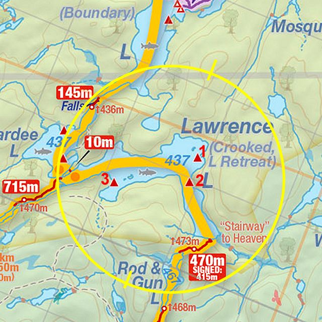
Thanks to Jeffrey McMurtrie of Jeff'sMap for supplying the base-layer map component by Creative Commons licensing.
Submitted by Stephen Molson, December 2009 .. visited May 2009.