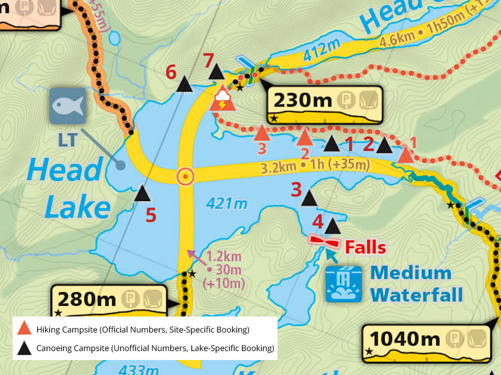
 Head Lake Campsite #5 Lat.-Long.: N45 31 03.7 W78 34 01.8
Landing
Topography of under-water approach: There were at least two possible approaches and landings - north-east and south. Both are over 2-4' of water depending on water level, and the surrounding shoreline granite sloped (south) or ~2' squared rock/boulders/shelf (north-east). A few emergent rocks near north-east landing area.
Impediments to disembarking from and/or unloading a canoe: The south approach is an inclined rock - making it slick depending on your footing, and both approaches over relatively deep water - making it a bit tricky to load/unload without scrapping your vessel. A strong south, north or east wind will make landings more challenging.
Topography to tent sites: Very light taper uphill along the mostly rocky point, with some shallow soil/grass up from landing leading to campsite. Very firm footing throughout. Campsite is roughly 2 meters or so higher than water level (depending on time of year).
Photo: Campsite's southern landing area.

![]()
Photo: North view from campsite's northeast landing.

![]()
Photo: East view from campsite.

![]()
Photo: Firepit and tenting location. Three raised redpine trunks delineated the seating.

![]()
Campsite
Campsite Maintenance: Regular.
Size of open area 90' x 140'. Extent of tree cover 80% canopied over tent/kitchen area.
Degree of levelness Flat around firepit and all tenting areas - even the landings were flat once up on the rock.
Number of level tent sites: At least 3 flat designated tenting sites adequate for3-4 man sized tents.
North exposure: Easterly canoe landings exposed to direct north winds, south landing protected. Two tentsites and the firepit not well protected from north winds - only a thin tree line for a windbreak. Existing tarp windbreak provides good north wind protection on table when using stove/managing food.
East exposure: Both landings fully exposed to strong east winds, campsite/firepit also only thinly protected from easterlies.
South exposure: Southern exposure from canoe landing only and 1 of the tenting sites.
West exposure: Full protection from the west for the 3 tenting sites, landings and firepit. Campsite located on western shoreline and backs on to a thick coniferous forest.
General description: Great campsite!. At least 3 spacious and well laid out tent sites. Cooking area was fair and nicely protected. A large number of grills were present. Firepit well protected from all but strong easterlies and north winds. Great sunrise views and lots of sun exposure off point throughout the day - perfect for working on one's tan/drying gear. Thunder box located west of campsite. No issues with firewood. Lots of room on point to bring up your canoe(s)/Kayak(s).
Negative: Only fair to poor landing on account of the rock steepness, slope and exposure during winds.
Overall accessibility: Good
Photo: View south of firepit identifying the 2nd of 3 spacious tenting locations.

![]()
Thanks to Jeffrey McMurtrie of Jeff'sMap for supplying the base-layer map component by Creative Commons licensing.
Submitted by Stephen Molson, January 2010 .. visited May 2009.