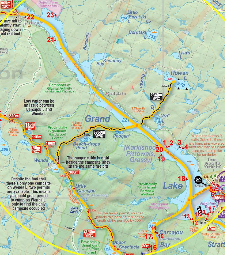
 Grand - Stratton Portage
Portage Trail
Length: according to CRAPP Map .. 50 meters
Portage maintenance: regular
Landing at Grand Lake .. Lat. N45 51 18.0 .. Long. W77 45 19.5 Landing at Stratton Lake .. Lat: N45 51 16.7 .. Long W77 45 16.9
Elevation above Sea Level @ Grand Lake: 223.5 m
Elevation above Sea Level @ St Andrews Lake: 223 m
Rise/Fall Overall: A mere 0.5 meters (at most) downriver to Stratton Lake side.
Portage Trail general description: Short and straight, with very easy firm ground.
Topographical impediments to traveling: None.
Areas susceptible to impact by periods of rain or beaver flooding: Early spring typical conditions would be high water on landing areas. But don't expect any flooding along the portage itself. There are no low lying or earthy sections prone to flooding. The current will be stronger on the Stratton Lake side in spring.
Landing at: Grand Lake (upstream)
Topography of under-water approach: Small sandy beach landing.
Available surface area for managing canoes: Room for at least 2 canoes + gear at a time if 1 is pulled up on shore. There is also a 2nd disembarking area closer to the spillway. And one also has the option to carry one's boat over the small dam/spillway.
Impediments to disembarking from and/or unloading a canoe: None.
Topography of the ascending grade: very little elevation grade.
Impediments to moving gear to portage trail: None. There's adequate pack layout area.
Canoe landing on Grand Lake side of portage to Stratton Lake (July 09) ...

Landing at: Stratton Lake (downstream)
Topography of under-water approach: Shallow rocky/sandy/pebbly river-side landing. There can also be some current present, depending on water levels. There's a 2nd landing for 1 canoe also available closer to dam.
Available surface area for managing canoes: Depending on water levels, at least 3 canoes can be pulled up along the river's edge. One could also walk the boat up and over the dam/spillway, depending on flow levels
Impediments to disembarking from and/or unloading a canoe: Possibility of strength to downriver current, depending on water level.
Impediments to moving gear to portage trail: None
Landing on Stratton Lake, looking southeast, downstream (Sept. ' 09). ...

Landing at Stratton Lake, looking west, upsteam (Sept. '09).
Note the low concrete dam up to the shore. One could haul a canoe over it if water conditions were favorable. ...

Thanks to Jeffrey McMurtrie of Jeff'sMap for supplying the base-layer map component by Creative Commons licensing.
Submitted by Stephen Molson, October 6, 2009