 Galeairy Lake Campsite #4
Landing
Topography of under-water approach: recommended landing is north of actual campsite. It has underwater rocks requiring careful approach.
Impediments to disembarking from and/or unloading a canoe: Stepping out on to rocks, steadying canoe and transferring packs to firm level ground located about 18 inches higher, is best as a two-person process.
Topography to tent sites: A rising trail through open forest leads SSE to the campsite.
Landing's canoe and unloading locations .. north of the campsite ...

![]()
Level area above landing, which is immediately behind low bushes ...

![]()
Trail leads up grade to the campsite (note blue tarp beyond canoe & trees) ...

![]()
Campsite
Regular or low-maintenance: Regular
Size of open area: Very large exposed area.
Extent of tree cover: West edge of forest offers some tree cover.
Degree of levelness: Level areas are scattered about. Overall, the site has pronounced slope to the water, to the west.
Number of level tent sites: 3 tent sites.
A hard-packed area, provides space for two tents at a distance from the firepit (photo by Bill Warren) ...

![]()
The firepit is fully exposed to the west wind and has no capability of being 'tarped' ...

![]()
The rock point provides a great view of the lake ...

![]()
North exposure: Dense forest.
East exposure: Dense forest.
South exposure: Open to the channel which leads to the eastern part of the lake.
West exposure: Wide open to the lake's west bay, its winds and sunset view.
General description: Spacious larger campsite. Being on an exposed point, wind can be a problem. Without possibility of tarping the firepit, it can be a 'bleak' experience in the rain and/or wind.
Overall accessibility: Landing access can be a distinct challenge, particularly when waves are pounding ashore. The distance to be walked up and down to the tentsites from the landing could be tiresome.
Campsite from the water (photo by Bill Warren) ...

![]()
Sunset view from the campsite's rock point ...

![]()
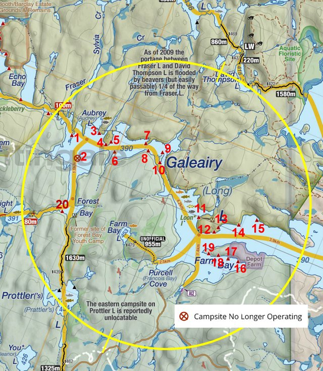
Thanks to Jeffrey McMurtrie of Jeff'sMap for supplying the base-layer map component by Creative Commons licensing.
Submitted by Barry Bridgeford .. September 2013 .. Visited June, 2013