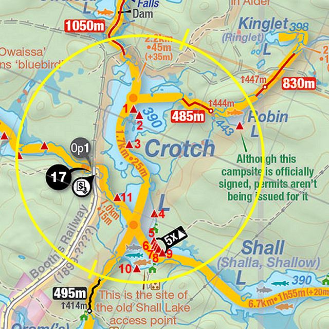
 Crotch Lake Campsite #3
Landing
Topography of under-water approach: Sand and gravel slope.
Impediments to disembarking from and/or unloading a canoe: None.
Topography to tent sites: Loose gravel rise.
 |
|
| Sand and gravel slope into the water. | |
 |
|
| Rocky rise toward the first two tentsites on the left. | |
 |
|
| Trail rises up to firepit area & other tentsites. | |
Campsite
Campsite maintenance: Regular.
Size of open area: Two small level tentsites amongst and under the trees near to the water. 25' x 35' open area at the top of the rise.
Extent of tree cover: Tree cover over first two tent sites. Less dense canopy over firepit area at the top of the rise.
Degree of levelness: While the campsite is on a substantial grade, each of the three components is level.
Number of level tent sites: 2 small ones close to the water and 2 larger ones at the top of the rise.
North exposure: Line of trees provides broken view of the lake.
East exposure: Trees.
South exposure: Trees.
West exposure: Trees break the view of the lake.
General description: Unique campsite on a bit of a point, with large firepit area at the top of a rise, a choice of private or not-so-private tentsites, and a tree-filtered sunset view.
Overall accessibility: Substantial grade requires fair bit of up-and-down walking to-and-from the water.
 |
|
| Two small tentsites are close to the water amongst the trees (looking west). Photo: Bill Warren |
|
 |
|
| Firepit area has plenty of room for a couple of tents (and a view to the north). | |
Thanks to Jeffrey McMurtrie of Jeff'sMap for supplying the base-layer map component by Creative Commons licensing.
Submitted by Barry Bridgeford .. Visited June 2014 .. Submission November, 2016