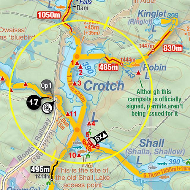
 Crotch Lake Campsite #2
Landing
Topography of under-water approach: Sand and gravel slope.
Impediments to disembarking from and/or unloading a canoe: None.
Topography to tent sites: Moderate dirt and root rise.
 |
|
| Campsite as seen from the water. | |
 |
|
| Rise from the water to the actual campsite. | |
 |
|
| Looking down to the landing. | |
Campsite
Campsite maintenance: Regular.
Size of open area: Primary firepit and tentsite area is 20' x 35', with secondary area downgrade to the south.
Extent of tree cover: Mature conifers provide extensive canopy with ample open ground level.
Degree of levelness: Two level areas separated by slight grade.
Number of level tent sites: 1 by firepit and 2 more to the south on a slightly lower area.
North exposure: Line of trees provides broken view of the lake.
East exposure: A few small trees and main view of the lake.
South exposure: Trees.
West exposure: Trees.
General description: Located on a bit of a point facing northeast, with firepit at the top of a rise. This site gets the sunrise, but definitely neither the afternoon sun nor the sunset.
Overall accessibility: Grade up from the water requires a bit of up-and-down walking to-and-from the water.
 |
|
| The firepit area overlooks the lake. | |
 |
|
| Tentsite in foreground and firepit area beyond. | |
 |
|
| A couple more tentsites are downgrade, to the south of the firepit area. | |
 |
|
| The view over the lake includes a small island. | |
Thanks to Jeffrey McMurtrie of Jeff'sMap for supplying the base-layer map component by Creative Commons licensing.
Submitted by Barry Bridgeford .. Visited July, 2023 .. Submission August, 2023