 Bonnechere Lake Campsite #5
Landing
Topography of under-water approach: The campsite's rock point slopes down to the water on the east side. There's an organic bottom to the small landing area.
Impediments to disembarking from and/or unloading a canoe: Stepping out into mucky water to unload is to be expected. Grade immediately starts at water's edge.
Topography to tent sites: 25' rise over distance of about 40' to the tentsite and firepit areas which are on different levels.
Small landing area is behind the point ...

![]()
Mucky landing area alongside sloping rocks...

![]()
Ascending slope rises immediately from the water ...

![]()
Campsite
Campsite maintenance: regular
Size of open area: Series of small open areas on different levels comprise the campsite.
Extent of tree cover: Pine and cedar trees are quite dense over the entire campsite.
Degree of levelness: Campsite has number of small level areas at different heights.
Number of level tent sites: Separate level areas for three medium size tents.
Trail up from the water to the campsite ...

![]()
Small firepit area is blocked from the lake by trees ...

![]()
Tentsites are deep within the trees, without a view of the lake ...

![]()
North exposure: Forest is dense on the north end of the point.
East exposure: Forest is dense.
South exposure: View of the lake is blocked from firepit and tentsites by pines and cedars. A separate lower open area under the pines provides a view of the lake to the south.
West exposure: One small elevated area gives a very limited view of the lake.
Looking west through the trees and across the lake, from a single small vantage point ...

![]()
General description: This campsite is extremely confined. While it definitely provides shelter from cold shoulder-season winds .. it will be a stuffy, buggy and unattractive during the summer. The only open breezy area is on a lower level closer to the water on the southwest side of the point.
Overall accessibility: The mucky landing, steep ascent and multi-levels could be troublesome to young children and some seniors.
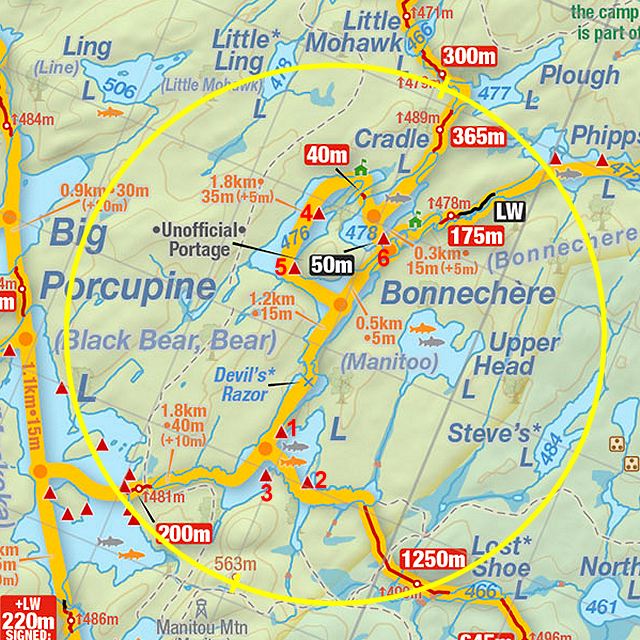
Thanks to Jeffrey McMurtrie of Jeff'sMap for supplying the base-layer map component by Creative Commons licensing.
Submission February, 2015 by Barry Bridgeford .. visited July, 2011