 Big Porcupine Lake Campsite #4
Landing
Topography of under-water approach: Flat area with variety of smaller rounded rocks.
Impediments to disembarking from and/or unloading a canoe: A rounded rock shelf provides an irregular somewhat high unloading and disembarking area during typical water levels. Under rainy conditions, care would be required.
Topography to tent sites: Approximately 20' moderate climb to the firepit area and a slight grade from there to the tentsite area.
 |
|
| - A curved rock shelf provides an easy landing when water levels are adequate. | |
 |
|
| - Looking down from the rounded shoreline rock shelf. | |
 |
|
| - Top of rock could serve as preparation area for loading gear back into canoes. | |
 |
|
| - Last part of rock rise to the firepit area, with the bushy forest behind. | |
Campsite
Campsite maintenance: regular
Size of open area: Lack of ground-cover under the red-pines leaves a very large area "open".
Extent of tree cover: Red-pines cover the tentsite area, with light coming in under canopy from both the lakeside and the inland low brush area. However, the firepit area is very much open to the sky.
Degree of levelness: The firepit and tentsite areas are generally flat with a slight rise between them.
Number of level tent sites: Sufficient room for a number of tents.
North exposure: While the campsite is elevated above lake-level, the trunks of red-pine block some of the north wind.
East exposure: Brush and forest block the east wind.
South exposure: Forest blocks the firepit area from the south wind. The tentsite area is more open to the south wind.
West exposure: Wide open to the lake, providing a great view from SW through to NW. However, there's little protection from bad weather out of the same directions.
 |
|
| - Looking toward the campsite from the trail that leads to the thunderbox. | |
 |
|
| - Open firepit area and the red-pine canopied tentsites beyond. | |
 |
|
| - The tentsites amongst the red-pines are open to off-the-lake breezes. | |
General description: Great campsite for a large group, with good afternoon sun exposure and sunset views. However, in bad weather, it would be very hard to shelter the firepit area.
Overall accessibility: Requires fair bit of climbing from and to the landing.
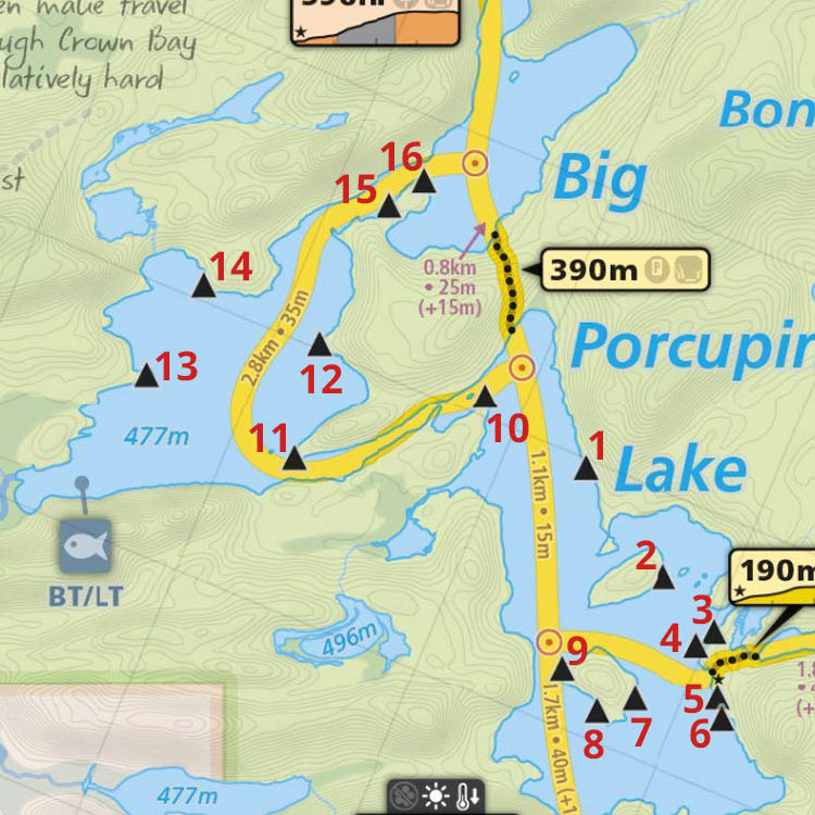
Thanks to Jeffrey McMurtrie of Maps By Jeff for supplying the base map.
Submission April, 2012 by Barry Bridgeford .. visited July, 2011